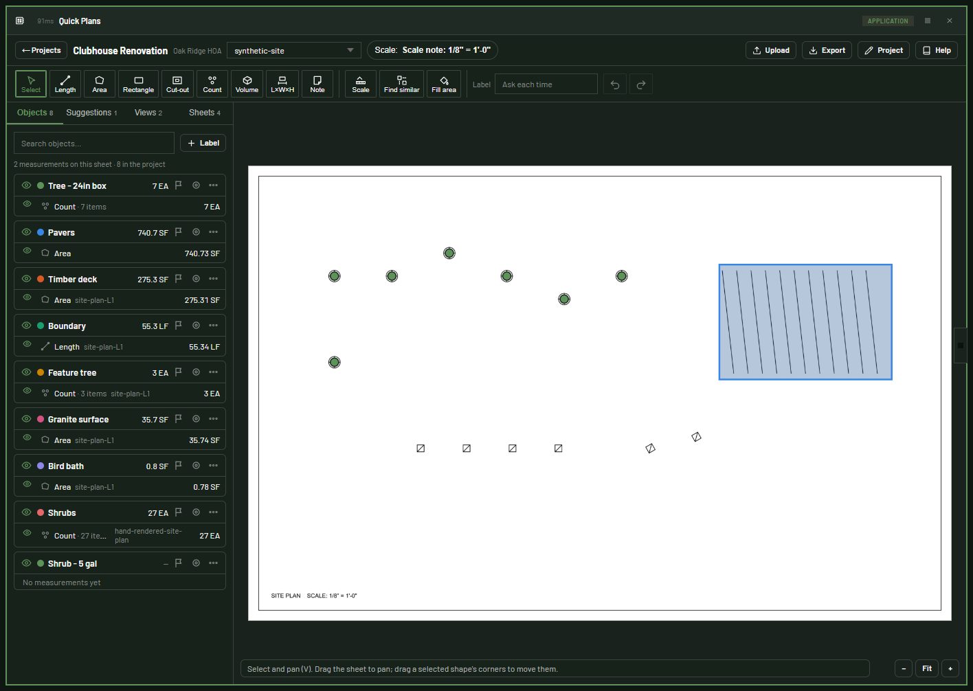
Overview
Quick Plans measures quantities from drawings: the square feet of a patio, the linear feet of edging or wall, how many trees or fixtures, the cubic yards of mulch or concrete. It works for any trade — landscape, hardscape, framing, plumbing, electrical — because you name what you measure.
Drawings come from many architects and designers. Some are clean CAD files with a scale and a key; some are scanned or hand-coloured images with no scale at all. Quick Plans handles both: set the scale once per sheet (from the scale note, a standard scale, or two clicks on any known length), then measure by hand. Suggestions from AI and symbol detection speed it up, but nothing is counted until you accept it.
OfficeNew project→Upload drawing→Set the scale→Measure and labelreview→Flag for bid→Export
SuggestionsAI readSymbols & areas (exact)Find similaryou accept→Measurements
Where things are
- Left nav → Takeoff projects — every project as a card. New project starts one.
- A project opens the workspace:
- Top bar — the sheet you are on, its scale (click it to change it), Upload, Export, Project and Help.
- Toolbar — Select, Length, Area, Rectangle, Cut-out, Count, Volume, L×W×H, Note, Scale, Find similar and Fill area, plus the Label new measurements get, and Undo / Redo.
- Left panel — four tabs:
- Objects — everything measured, counted or found, grouped by label, with totals. Each measurement is a row with its type and quantity; click it to zoom to it on the drawing. Click a label to fold it.
- Suggestions — what the AI read and the detectors found, waiting for you to accept or reject.
- Views — saved views: a sheet, a zoom and which labels are shown.
- Sheets — the drawings in the project and their pages.
- The drawing on the right. Drag to pan, scroll (or pinch) to zoom, Fit to see the whole sheet. Click a shape to select it.
- Inspector — the selected measurement's quantity, label, depth, notes, Flag for bid and, for areas and counts, Find similar to this.
What it measures
| Kind |
Unit |
How |
| Length |
LF (m) |
Click points along it |
| Area |
SF (m²), with perimeter |
Click the corners, or drag a rectangle; cut-outs subtract |
| Count |
EA |
Click each item |
| Volume |
CY (m³) |
An area × a depth |
| Dimensions |
LF, SF or CY |
Type L, L×W or L×W×H rows — no drawing needed |
| Note |
— |
A note pinned to the sheet |
See Reference for scales, units and conversions, and How-tos for each task.
How-tos
Each how-to says who can do it. If a button or tool is missing, you may not have that access; see Who can do what.
Start a takeoff project
Who can do this: people who can edit takeoffs.
- Left nav → Takeoff projects → New project.
- Type the Name. Add the Client and the Architect / designer if you know them (the firm lets Quick Plans remember that firm's symbols).
- Pick Imperial (LF, SF, CY) or Metric (m, m², m³).
- Click Create.
Expected result: the empty workspace opens with Upload a drawing.
Upload a drawing
Who can do this: people who can edit takeoffs.
- Open the project → Upload (top bar), or drop files onto the drawing area.
- Pick one or more files: PDF (every page becomes a sheet), PNG, JPEG, WEBP or DXF.
- Wait for Processing to finish (left panel → Sheets). Large PDFs take a minute.
Expected result: each page shows in the sheet picker in the top bar. A PDF with a printed scale note (for example 1/8" = 1'-0") gets a Scale note suggestion. A DXF gets its scale from its own units straight away.
DWG, IFC and STEP files are kept with the project but can't be measured: export a PDF or DXF of the drawing from the CAD program and upload that. See Supported files.
Set the scale by calibrating
Who can do this: people who can edit takeoffs.
Use this on any drawing, including images with no scale.
- Open the sheet → Scale tool (K) in the toolbar, or click the No scale — set it chip in the top bar → Calibrate.
- Click the two ends of something whose real length you know: a dimension string, a scale bar, a property line, a door (3 ft), a parking stall. Zoom in first for accuracy.
- Type the real length and pick its unit (ft, in, m, mm…).
- Click Set scale.
Expected result: the top bar shows Scale: Calibrated: 20 ft and every length and area on the sheet is recalculated.
The scale belongs to the sheet: set it once, then measure. To measure something (a sidewalk, the other side of a pool) use Length (L), not Scale.
Check the scale on a second known length
Who can do this: people who can edit takeoffs.
When the sheet already has a scale, the Scale tool checks it instead of replacing it.
- Scale tool (K) → click the two ends of another length you know (the other side of the pool, a second dimension string).
- The dialog shows how far apart they are with the current scale, e.g. 58.4 ft apart.
- If that's right, click Keep scale. If not, type the real length: the dialog shows how far off the scale is, in percent.
- Choose Average both when both lengths are trustworthy (the scale becomes the average of your calibrations), or Recalibrate to use only the new length.
Expected result: Keep changes nothing; Average shows Calibrated: average of 2 in the top bar; Recalibrate shows the new length. Every measurement on the sheet is recalculated.
The AI read can also suggest a scale from the sizes printed on the plan (room sizes, dimension strings). It says how many of them agree — check it with this step before you trust it.
Set a standard scale
Who can do this: people who can edit takeoffs.
- Click the scale chip in the top bar.
- Under Standard scale, pick one: architectural (1/8" = 1'-0" …), engineering (1" = 20' …) or metric (1:50 …). Or type 1:N.
- On an image, also type its paper resolution (pixels per inch) — a PDF already knows its paper size.
- Click Set scale.
Expected result: the chip shows the scale you picked. Check it once: measure a dimension that is printed on the drawing and compare.
Measure a length
Who can do this: people who can edit takeoffs.
- Type a Label in the toolbar (for example Steel edging), or leave it empty to be asked each time.
- Pick Length (L).
- Click along the line. Hold Shift for straight 45° / 90° segments. Points snap to existing corners.
- Double-click, press Enter, or click the last point again to finish. Backspace removes the last point; Esc cancels.
Expected result: the line is drawn in the label's colour, the label's total in the left panel grows, and the inspector shows the length.
Measure an area
Who can do this: people who can edit takeoffs.
- Pick Area (A) and click each corner. Click the first point (or double-click, or Enter) to close it.
- For a rectangle, pick Rectangle (R) and drag from corner to corner.
- To subtract a part (a planter in a patio, a tree hole in a deck): select the area, pick Cut-out (H) and outline the part.
Expected result: the area shows in square feet (or m²) with its perimeter in the inspector.
Count items
Who can do this: people who can edit takeoffs.
- Set the Label (for example Shrub — 5 gal).
- Pick Count (C). The bar at the bottom says what your clicks do:
- New count: Shrub — 5 gal — nothing was selected, so this starts a new count.
- Adding to Maple Tree (6 already) — a count was selected, so the clicks are added to it. Click New count instead to start a separate one.
- Click each item, then press Enter or click Save / Add on the bar. Cancel (or Esc) throws away the clicks not saved yet.
Expected result: one count measurement with a marker on each item, listed under its label in Objects. Each Count you save is its own row there, so two saves of 3 trees show as two rows and 6 in the label's total. To take one out later, select it with Select, click the marker, then Remove the selected item in the inspector.
Get a volume from an area and a depth
Who can do this: people who can edit takeoffs.
- Pick Volume (U) and outline the area, or select an existing area → Make it a volume (add depth).
- Type the Depth and its unit (for example 3 in of mulch, 4 in of concrete).
- Click Save.
Expected result: the quantity shows in cubic yards (m³ on metric projects): area × depth ÷ 27, for example 1,065.95 SF × 4 ft = 157.92 CY. Change the depth in the inspector at any time.
Volume makes a new measurement under the label in the Label box; it doesn't change the item you had selected. To give an area you already drew a depth, select it and use Make it a volume instead.
Enter dimensions without drawing
Who can do this: people who can edit takeoffs.
Use this for things you estimate from L × W × H — footings, walls, a room from the dimensions on a detail.
- Pick L×W×H (D).
- Type the Label, choose Length, Area or Volume, and the unit the dimensions are in.
- Add a row per piece: where / what, L, W, H and how many (×).
- Click Save.
Expected result: one Dimensions measurement whose total is the sum of the rows; it adds into the label's total like any other measurement.
Pin a note to the drawing
Who can do this: people who can edit takeoffs.
- Pick Note (N) and click where it belongs.
- Type the note → Pin note.
Expected result: a pin with the text on the sheet. Notes are not quantities and are not exported.
Label, colour and flag items for the bid
Who can do this: people who can edit takeoffs.
- Left panel → Objects. Each label lists its measurements; click the ⋯ button for its settings.
- Change the Name, Category, Colour or Show quantities in (SF or SY, LF or m…).
- Tick Flag for bid for the label, or tick Flag for bid on one measurement in the inspector.
- To move a measurement to another label, change Label in the inspector. To combine two labels, use Merge into.
Expected result: flagged labels show a highlighted flag, and the flagged for bid export lists them.
Link a label to the Price Book
Who can do this: people who can edit takeoffs (the tenant needs the Price Book & Vendors module).
- Open the label's settings (⋯).
- Under Price Book product, type and pick the product.
- Optional: under Convert the total, turn the measured quantity into what you buy:
- Divide — e.g. SF ÷ 450 into pallets of sod.
- Multiply — e.g. EA × 2 into bags.
- Area × depth → volume — e.g. 3 in deep into CY of mulch.
- Add Waste % and Round up if you like.
- Click Save.
Expected result: the label's total shows the converted amount under it (= 12 pallets), and exports carry the product name. Without the Price Book, the label keeps a name only.
Hide labels and show one at a time
Who can do this: everyone.
- Left panel → Objects. Click the eye on a label to hide it on the drawing.
- Click the target button to show only that label; click it again (or Show all) to bring the rest back.
Expected result: the drawing shows only what you chose; totals don't change.
Save a view and open it again
Who can do this: saving needs edit access; anyone can open a saved view.
- Zoom to the part of the sheet you want, hide or solo labels, select an item.
- Left panel → Views → type a name (for example Back patio) → Save.
- Later, click the view in the list.
Expected result: the same sheet, zoom, position and visible labels come back. The ↺ button replaces a view with what is on screen now.
Read a sheet with AI
Who can do this: people who can edit takeoffs (and the AI read is switched on in Settings).
- Open the sheet → left panel → Suggestions → AI read of this sheet.
- Wait about a minute.
- Review what came back:
- Title block — project, firm, date, scale text (the firm is filled in on the drawing).
- Scale — from the scale note or the scale bar. Use this scale, then check one printed dimension.
- Legend / key — Add label, or Find these to count every symbol like it.
- Callouts — Label only, Fill area at arrow (traces the area the arrow points into) or Count at arrow.
- Objects the AI saw — trees, shrubs, pavers… with boxes. Take wrong ones out, then Count.
- Reject what is wrong.
Expected result: accepted items become ordinary measurements; rejected ones disappear. Read AI suggestions and their limits before relying on AI counts.
Analyze a sheet with AI
Who can do this: people who can edit takeoffs. Needs the company's AI provider.
- Left panel → Suggestions → Analyze this sheet.
- Under What should it look for?, say what you need, for example Identify all exterior landscaping and hardscaping. Count and measure trees, walkways, patios, terraces, water features, bushes. Or click Landscape & hardscape, Plants only, Hardscape only or Everything. It's saved with the project.
- Click Analyze and wait about a minute.
- Review the suggestions: Scale, Objects the AI saw (each counted across the whole sheet, with a Similarity slider), Areas (traced outlines with square feet), Legend and Callouts. Name each one and Count / Add area, or Reject it.
Expected result: suggestions only — nothing is counted until you accept it. Whatever you already measured on the sheet isn't suggested again; a suggestion that overlaps it says Already added as … (click Dismiss, Show mine to see yours, or Add anyway). On PDF and DXF the exact symbols and areas from the line work are added too.
Find every symbol like this one
Who can do this: people who can edit takeoffs.
- Pick Find similar (F).
- Drag a box tightly around one symbol (one tree, one fixture).
- Wait a few seconds. The matches appear as dashed boxes and as a suggestion in the left panel.
- Move the Similarity slider: lower finds more look-alikes, higher only close copies, and the boxes and the count update as you drag. Click any wrong box on the drawing to take it out (click again to put it back). Crossed-out boxes were set aside because their colours differ; click one to put it back. Symbols turned to another angle are found too.
- Name it and click Count.
Expected result: a count measurement with a marker on each kept match.
Find similar to a shape you drew
Who can do this: people who can edit takeoffs.
- Select an area (for example the outline of one tree canopy) or a count, on the drawing or in Objects.
- Inspector → Find similar to this. For an area, its outline is the symbol searched for. For a count, drag a box around one of its symbols.
- Review the matches as in Find every symbol like this one. The shape you started from is already taken out.
- From an area: Add N areas copies your outline onto every match (or Count N to count them). From a count: Add N to the count adds the matches to it (or New count).
Expected result: the new areas, or the larger count, under the same label in Objects.
Find symbols and areas on a CAD drawing
Who can do this: people who can edit takeoffs.
On PDFs exported from CAD and on DXF files, Quick Plans can read the line work itself — exact, not a guess.
- Left panel → Suggestions → Find symbols & areas (exact).
- Review Symbols found (Symbol A — 14 found, or the DXF block name) and Areas (closed and hatched shapes, with their exact area).
- Name a symbol group once and Count; Add area for areas you need.
Expected result: exact counts and areas. Scanned PDFs have no line work: use Find similar there.
Trace an area by clicking inside it
Who can do this: people who can edit takeoffs.
- Pick Fill area (G) and click inside a coloured, shaded or outlined area.
- If it leaks out or stops short, change Tolerance (how different a colour may be) or Close gaps (jumps across thin lines and hatching) at the bottom and click again.
- Save area.
Expected result: an area measurement following the region's outline, holes included.
Remember symbols for a firm
Who can do this: people who can edit takeoffs; editing the library needs the settings permission.
- When you accept a symbol group, an object or a legend entry, tick Remember for firm (type the firm if the drawing doesn't have one yet).
- On the next drawing from the same architect or designer, the same symbols come up already named (and with the label's Price Book product).
- Administrators: module settings (⋮ on the sidebar row) → Configuration → Symbol library to rename, re-file or remove entries.
Expected result: later suggestions from that firm carry your names instead of Symbol A.
Undo a mistake
Who can do this: people who can edit takeoffs.
- Click Undo (or Ctrl+Z) — it reverses the last measurement you added, changed or deleted.
- Redo (Ctrl+Y) puts it back.
Expected result: the measurement and the totals return to how they were. Undo covers this session's measurement changes, not label or scale changes.
Export quantities
Who can do this: everyone who can see the project.
- Open the project → Export (top bar).
- Pick Excel workbook (by label, by sheet, flagged for bid and every measurement) or one CSV.
Expected result: the file downloads. Quantities are per label and unit; converted amounts and Price Book products are included.
Reference
| Tool |
Key |
What it does |
| Select |
V |
Select a shape (click), pan (drag), move a selected shape's corners (drag a handle) |
| Length |
L |
Polyline; total length |
| Area |
A |
Polygon; area and perimeter |
| Rectangle |
R |
Drag a rectangular area |
| Cut-out |
H |
Subtract a polygon from the selected area |
| Count |
C |
One marker per click; Enter saves |
| Volume |
U |
Area × depth |
| L×W×H |
D |
Typed-in dimension rows |
| Note |
N |
A note pinned to the sheet |
| Scale |
K |
Calibrate on two points; with a scale set, check it (keep, average or recalibrate) |
| Find similar |
F |
Box one symbol, find the rest |
| Fill area |
G |
Trace the area around a click |
Also: Enter finishes, Esc cancels, Backspace removes the last point while drawing, Delete deletes the selected measurement, Shift keeps 45° angles, Space-drag pans, + / − / 0 zoom in, out and fit, Ctrl+Z / Ctrl+Y undo and redo. On a tablet: drag to pan, pinch to zoom, tap to place a point.
Points snap to the corners of other measurements within about 10 screen pixels.
Units
| Measures |
Imperial |
Metric |
Also available per label |
| Length |
LF |
m |
yd, ft |
| Area |
SF |
m² |
SY, acres |
| Volume |
CY |
m³ |
CF |
| Count |
EA |
EA |
— |
Depths can be typed in in, ft, mm, cm or m. Dimension rows can be in ft, in, yd, m, cm or mm.
Scales
A sheet's scale is stored as real feet per sheet pixel, set one of three ways:
- Calibrate — two points and their real distance. Works on everything, including images.
- Standard scale — needs the paper size. PDFs know it; for an image, type its pixels per inch.
- Architectural: 1/16", 3/32", 1/8", 3/16", 1/4", 3/8", 1/2", 3/4", 1", 1-1/2", 3" = 1'-0".
- Engineering: 1" = 10', 20', 30', 40', 50', 60', 100', 200'.
- Metric: 1:1, 1:5, 1:10, 1:20, 1:25, 1:50, 1:100, 1:200, 1:250, 1:500, 1:1000.
- From a DXF — the drawing's own units (inches, feet, millimetres, metres…). Exact.
Each sheet has its own scale. Changing it recalculates every measurement on that sheet. Lengths and areas drawn before a scale is set are kept and show no scale until it is set.
A drawing printed "not to scale" or resized after printing will not match its printed scale note. Always check one printed dimension after setting a scale.
How quantities are calculated
- Length — the sum of the segments.
- Area — the polygon's area (shoelace formula) minus its cut-outs; perimeter is the outer edge only.
- Volume — area × depth, in CY (27 CF) or m³.
- Count — the number of markers.
- Dimensions — the sum over rows of L × count, L × W × count or L × W × H × count.
The server recalculates every saved quantity from the shape and the sheet's scale; the numbers shown while drawing are a preview.
Conversions
A label can turn its total into what you buy:
| Conversion |
Example |
| Divide |
4,500 SF ÷ 450 SF per pallet = 10 pallets |
| Multiply |
40 EA × 2 = 80 bags |
| Area × depth → volume |
1,080 SF × 3 in = 10 CY |
Waste % is added after the conversion, then Round up rounds to whole units.
Supported files
| File |
Status |
| PDF |
Supported. Every page (up to 60) becomes a sheet. Vector (CAD) PDFs also support exact symbol and area detection. |
| PNG, JPEG, WEBP |
Supported. One sheet; up to 5,000 pixels on the long side is kept. |
| DXF |
Supported. Model space is drawn; the scale comes from its units; blocks are counted exactly. |
| DWG |
Kept, not measured. Upload a PDF or DXF export. |
| IFC, STEP |
Kept, not measured. Upload a PDF or DXF export (plan view). |
Files up to 150 MB.
AI suggestions and their limits
The AI read sends the sheet image (and a PDF's own text) to the AI model set in Settings, using your company's AI key. It returns:
- the title block (project, firm, date, scale text);
- the scale — from the scale note (1:50, 1/8" = 1'-0") and from the scale bar, whose ends are tightened to the drawn bar before the scale is suggested;
- legend / key entries with the symbol's location;
- callouts — label text and where its arrow points;
- objects it recognizes, with boxes and a confidence.
Limits — read these before trusting a number:
- Counts are suggestions. On dense planting plans the AI marks the objects it can see, often not all of them. Use Find similar or exact detection for the real count.
- Locations are approximate (a few percent of the sheet). A scale from the AI is a starting point: check a printed dimension.
- Keys can be wrong or different between firms. The AI reports what the key says; you decide.
- Areas come from Fill area at a callout's arrow, not from the AI drawing outlines.
- Nothing is counted until you accept it. Every call uses your company's AI key and shows in AI usage.
Find similar compares shapes (or colours) to the symbol you boxed. Hand-drawn symbols vary, so expect a few misses and false matches: take wrong ones out before you count. Auto-find repeated shapes is a best effort on images and works best on clean line drawings.
Exact detection (vector PDFs and DXF) reads the drawing's own lines: counts and areas are exact for what is drawn, but a symbol drawn in different ways (split lines, different sizes beyond about 8%) can form two groups.
Who can do what
| Someone who… |
Can |
| Views takeoffs (Admin, Operator, Viewer by default) |
Open every takeoff project, its drawings, measurements, totals and saved views; hide and show labels; export quantities |
| Edits takeoffs (Admin, Operator by default) |
Everything above, plus: create projects, upload drawings, set scales, measure, label, flag for bid, link the Price Book, save views, run the AI read and symbol detection, accept or reject suggestions, remember symbols for a firm |
| Manages Quick Plans's settings (Admin by default) |
Change the AI model and defaults, and rename or remove entries in the symbol library |
A tenant administrator can change who has which access under System Settings → Users & Roles.
The AI read uses your company's own AI key; each read shows in the AI usage report.
Permission codes
| Code |
Meaning |
| PLAN_TAKEOFF.VIEW |
View takeoffs and export |
| PLAN_TAKEOFF.EDIT |
Edit takeoffs |
| PLAN_TAKEOFF.MANAGE_SETTINGS |
Settings and the symbol library |
Questions
My lengths and areas say "no scale"
The sheet has no scale yet. Click the scale chip in the top bar and calibrate on any known length. Everything you already drew is recalculated.
The drawing is an image with no scale and no dimensions
Find something whose size you know — a door (about 3 ft), a parking stall (about 9 ft wide), a standard sidewalk (often 4 or 5 ft), a property line with a bearing and distance — and calibrate on it. Then measure the rest, or type pieces in with L×W×H.
The standard scale gives the wrong numbers
The drawing was probably resized when it was printed or saved (fit to page, a screenshot, a different paper size). Calibrate on a printed dimension instead.
Can I upload DWG?
Not yet. DWG, IFC and STEP files are kept with the project, but export a PDF or DXF from the CAD program to measure. See Supported files.
Why did the AI miss some trees?
The AI marks what it can see and gives an estimate; on dense plans that is rarely every one. Use Find similar on one tree for the real count, and take out wrong matches. See AI suggestions and their limits.
Does the AI read cost money?
Each AI read is one call to your company's AI provider with your key, and shows in AI usage. Measuring by hand, Find similar, Fill area and exact detection don't use AI.
Where do the quantities go for the bid?
Export them (Excel or CSV), or flag labels for bid and export the flagged list. Estimating will be able to read takeoff quantities directly in a later version.
Two labels should be one
Open one label's settings (⋯) → Merge into → pick the other → Merge. Its measurements move over.
Can two people work on the same project?
Yes. Each change is saved immediately. Click a sheet again (or reload) to see what someone else added.
I set the scale twice. Which one counts?
The scale belongs to the sheet, and there is one per sheet (it shows in the top bar). Since 0.1.1, using Scale again on a sheet that already has one checks it: you see how far apart your two points are with the current scale, then choose Keep scale, Average both or Recalibrate. Before 0.1.1 the second calibration simply replaced the first. See Check the scale.
I calibrated the pool's length at 60 ft. How do I get its width?
Use Length (L), not Scale: click both ends of the width and it shows the distance in feet from your calibration (for example 20 ft). Scale is only for telling the sheet how big it is; Length, Area and Count are for measuring.
The scale note says "SCALE 1:100" but can't set the scale
A 1:100 note means 1 unit on paper is 100 in real life. A PDF knows its paper size, so the note works there. An image (PNG, JPEG, a screenshot) has no paper size, so 1:100 can't be turned into feet. Calibrate on something you know instead (the pool, a dimension, a door). If the sheet is already calibrated, the note says it isn't needed: Dismiss it.
How is an area calculated?
From the outline you drew (or traced) and the sheet's scale: the shape's size on the sheet × (feet per pixel)². Change the scale and every area on the sheet is recalculated. Perimeter is the length around the outline. Cut-outs (H) are subtracted.
How is a volume calculated? Did it add to the item I had selected?
Volume = the area you outline × the depth you type, in cubic yards (cubic metres in metric). For example 1,065.95 SF × 4 ft ÷ 27 = 157.92 CY. Volume always makes a new measurement under the label in the Label box; it does not change the selected item. To turn an existing area into a volume, select it and click Make it a volume (add depth) in the panel on the right.
Where is the list of everything I measured, like layers?
The Objects tab (first tab on the left). Each label is a group with its total and an eye to show or hide it on the drawing (the target icon shows only that label). Under it, every measurement, count and area is its own row: click a row to zoom to it, then edit or delete it in the panel on the right.
Can I find similar from a shape I drew?
Yes. Select the area or count, then Find similar to this in the panel on the right. From an area, the matches can be added as areas of the same shape (good for tree canopies) or counted. From a count, box one of its symbols and the matches can be added to that count. The shape you started from is never counted twice. See Find similar to a shape you drew.
My count is higher than what I clicked. Is it a new count or the selected one?
The bar at the bottom says: New count: … starts a new count; Adding to … (N already) adds to the selected count (New count instead switches). Each count you save is its own row under the label in Objects, and the label's total adds them all up — two saves of 3 trees show 6. Delete a row you don't want. Before 0.1.1, clicking Cancel or Done on that bar could also add a point; that's fixed.
The AI found a pool or a terrace but shows nothing to count
Areas aren't counted, they're traced. Since 0.1.1 the AI read places each area and traces its outline, so it arrives under Areas with its square feet. If it saw the area but couldn't trace it (textured or hand-coloured drawings), the card says so and offers Trace it: click inside the area to trace it with Fill area, or draw it with Area. Run AI read again to get this on a sheet read before 0.1.1.
I can't delete a label
Since 0.1.2, deleting a label that still has measurements asks once, then deletes the label and its measurements together. To keep the measurements, Merge into another label instead.
On narrower screens the tool names move under the icons, then only icons show. Hover a tool to see its name, its keyboard key and how to use it.
The AI found the tables, but I see no boxes or markings on the drawing
Two things to check:
- Is it still a suggestion? Suggestions aren't on the drawing until you open them: click the card in Suggestions to see its dashed boxes. Nothing is counted until you click Count.
- Did you click "Add label"? That creates only the label (the name), with no measurements: the label shows No measurements yet. Use Count N on the suggestion to count the items.
Counts made from a suggestion or Find similar keep a box around each item (0.1.4); counts you click by hand show a marker on each item.
Find similar matched something wrong (stairs instead of a table)
Shape matching compares outlines, so a white stair can look like a white round table. Since 0.1.4, matches whose colours clearly differ from the symbol you boxed start crossed out (set aside). Before you click Count, click any wrong box on the drawing to take it out, or a crossed-out one to put it back. If it was already counted: Select, click the wrong marker, then Remove the selected item in the panel on the right.
Can I hide one object without hiding the whole label?
Yes. In Objects, each row has its own eye. The eye on the label hides all of them; the target icon shows only that label.
The similarity slider doesn't change anything
Since 0.1.5 it updates the boxes and the count as you drag. On a suggestion made before 0.1.5, click Re-run once first. If the slider is all the way down and something is still missing, box the symbol again a little tighter (just the symbol, not its surroundings) — a tight box matches better.
Find similar missed one that looks the same
It may be turned to another angle (chairs facing another way): since 0.1.5 those are found too. Otherwise lower the slider, or add it by hand: select the count, pick Count, click it, then Add.
The AI is suggesting something I already measured
Since 0.1.6 the AI is told what you've measured on the sheet and skips it, and a suggestion that overlaps one of your measurements says Already added as …: click Dismiss. Suggestions from an AI read made before 0.1.6 aren't marked: run Analyze this sheet again, or Reject all on this sheet first.
Can I tell the AI what to look for?
Yes. Analyze this sheet asks What should it look for? Write it in plain words (a list of objects is fine), or pick Landscape & hardscape, Plants only, Hardscape only or Everything. It's saved with the project. An administrator can set the default for projects without their own in Module settings (⋮ on the sidebar row) → Preferences → ai_read_instructions.
Where did "Auto-find repeated shapes" go?
It's part of Analyze this sheet now: every symbol the AI names is counted across the sheet automatically. The button only appears when the AI is switched off. For one symbol you pick yourself, Find similar (F) is still the quickest.
How do I select or move a counted item or an area?
Pick Select (V). Click inside the item (anywhere in its box, or on its marker) to select it; the panel on the right shows it. Drag it to move it: a counted item moves on its own (marker and box together), an area, line or note moves as a whole, and its quantity doesn't change. To reshape an area, drag its corner squares instead. Undo (Ctrl+Z) puts a move back.
What's new
0.1.7
- Select and move anything. With Select (V), click anywhere inside an item's box to select it (not only its outline), and drag to move it: one counted item (its marker and box together), or a whole area, line or note. The quantity stays the same; Undo (Ctrl+Z) puts it back. Corners still drag on their own.
0.1.6
- One button: Analyze this sheet. It replaces AI read of this sheet and Auto-find repeated shapes. The AI reads the title block, scale, legend and callouts and finds what you ask for; areas are traced; every symbol it names is then counted across the whole sheet (the same matching as Find similar, at any angle, colours checked), with the similarity slider on the card. On PDF and DXF it also reads the exact symbols and areas from the line work. Auto-find repeated shapes is still there when the AI is switched off.
- Tell it what to look for. Analyze asks What should it look for? — for example "Identify all exterior landscaping and hardscaping. Count and measure trees, walkways, patios, terraces, water features, bushes." — with quick choices (Landscape & hardscape, Plants only, Hardscape only, Everything). It's saved with the project and used next time; an administrator can set the company default in Module settings → Preferences.
- It knows what you already measured. What's on the sheet is sent along, so the AI doesn't suggest it again, and anything that overlaps something you measured shows Already added as … with Dismiss, Show mine or Add anyway. Items already counted are taken out of a new count.
0.1.5
- The similarity slider works as you drag. Find similar searches once, wide, and the slider then shows more or fewer matches instantly, on the drawing and in the count. Count takes what the slider shows. (Suggestions made before 0.1.5: click Re-run once.)
- Symbols turned to any angle are found. Find similar now also matches the symbol rotated (every 15°), so a table whose chairs face another way, or a tree drawn turned, is found too.
0.1.4
- Found items are boxed on the drawing. A count made from an AI suggestion or Find similar keeps the box each item was found in, drawn in the label's colour around its marker. Clicked counts still show markers only.
- Hide one object. Every row in Objects has its own eye, so you can hide one count or area and keep the rest of its label showing. Saved views remember it; Show all brings everything back.
- Fewer wrong matches in Find similar. Matches with the same shape but clearly different colours (a white stair next to a white table on blue water) start set aside: crossed out, with a note on the card, and one click puts one back. The starting similarity is now 50%, so rotated or slightly different copies are found too.
0.1.3
- Help: new answers in Questions on setting the scale twice, measuring a width after calibrating a length, 1:N scale notes on images, how areas and volumes are calculated, the Objects list, Find similar from a shape, new count vs adding to one, AI areas, and deleting a label.
0.1.2
- Delete a label with its measurements. Deleting a label that still has measurements asks once and deletes them too (or merge it into another label to keep them).
- Scale notes on images. A 1:100 note can't be turned into feet on an image (no paper size). When the sheet is already calibrated, the note now says it isn't needed and offers Dismiss.
- Toolbar fits the screen. On narrower screens the shortcut letters hide first, then the tool names move under the icons, then only icons show; hover a tool for its name, key and how to use it.
0.1.1
- Check the scale. On a sheet that already has a scale, the Scale tool now shows how far apart your two points are with the current scale. Type the real length to see the difference, then Keep scale, Average both or Recalibrate. A second calibration no longer silently replaces the first. See Check the scale.
- Scale from labelled sizes. The AI read also looks for printed sizes (dimension strings, room sizes such as 7.5X23.5M, a pool marked 60') and suggests the scale most of them agree on.
- Objects list. The first left tab is now Objects: every label is open by default and each measurement, count and area is its own row with its type and quantity. Click a row to zoom to it.
- AI areas come back as areas. The AI read now places each area it sees (pool, terrace, lawn, deck) and traces its outline, so it arrives as an area suggestion with its square feet. An area it names but can't trace shows Trace it (Fill area, with the name ready) instead of Count 0; anything it names without placing is left out.
- Count is clearer. The bar says whether your clicks start a new count or are added to the selected one (New count instead switches). Cancel and Done on that bar no longer add points, and clicks off the sheet are ignored.
- Find similar to this. Select an area or a count and click Find similar to this in the inspector. From an area, the matches can be added as areas the same shape (tree canopies, planters, pads) or counted; from a count, the matches can be added to that count. The shape you started from is never counted twice. See Find similar to a shape you drew.
0.1.0
First version.
- Projects, drawings (PDF, PNG, JPEG, WEBP, DXF) and sheets; DWG / IFC / STEP kept with a note to upload a PDF or DXF export.
- Scale by calibration, standard architectural / engineering / metric scales, or a DXF's own units.
- Length, area (with cut-outs and perimeter), rectangle, count, volume, typed-in L×W×H dimensions and notes; snapping, corner editing, undo and redo.
- Labels with colours, categories, flag for bid, Price Book product and conversions (divide, multiply, area × depth).
- Left list grouped by label with totals; click to zoom; hide, show and solo labels; saved views.
- Suggestions: AI read of a sheet, exact symbols and areas from vector PDFs and DXF, Find similar, Fill area, Auto-find repeated shapes; a symbol library per firm.
- Export to Excel and CSV: by label, by sheet, flagged for bid, every measurement.